Parker 400 Helicopter Rules and Regulations
Please review the Parker 400 Helicopter Rules before scrolling down to register a helicopter for the event.
Parker 400 Airspace:
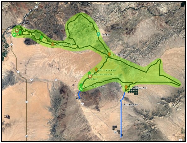
The airspace for this race will comprise approximately 760 square miles East of the 95 Fwy, and North of Highway 72 between Swansea to the North and Bouse and Graham Wells to the South.
The principal airport for race operations is Avi Suquilla Airport (FAA Identifier: P20), which is located 1.15 miles East of downtown Parker, Arizona. There is no control tower. Avi Suquilla offers fuel service and may have hot fueling options depending on staff availability. Please use standard North/South protocol when landing and taking off. Please do not approach East/West.
AVI Airport Communications CTAF/UNICOM: 122.725

Landing Zones:
Unless you have secured permission from a private property owner in the area, the Avi Suquilla Airport airport is the only designated landing zone in our air space.
Landing on BLM, CRIT, and/or State Trust land is prohibited unless it is an emergency.
Course Direction:
The Parker 400 racecourse will travel Counterclockwise
Navigation:
All aircraft must have a GPS enabled device with the racecourse loaded, prior to entering air space.
You must be able to effectively communicate your position.
We also strongly recommend a cellular-enabled tablet to track the race on the RacingTrax website.
The cellular coverage is good for 80% of the racecourse.
Communications:
The Parker 400 helicopter race frequency for communicating to other helicopters is: 130.30
All helicopters must be actively monitoring this radio frequency while in the Parker 400 airspace.
Communicating with competitors or relaying information to pits from helicopters is considered cheating and is not allowed at the Parker 400. Those caught doing so will be penalized.
The Parker 400 Race Operations frequency is: Weatherman = 151.625
How to report your position during the race:
Please start by identifying your color and helicopter type.
Every mile for the course has a mile marker that corresponds to that mile. To report your position refer to your racecourse map. Locate your position relative to the course and report the nearest mile marker.
EX: “This is the blue A-Star, I’m at race mile 65 near the entrance of Pit B.”
Altitude Policy:
Please orbit COUNTERCLOCKWISE at the Start/Finish line.
This is to ensure that as racers leave the start line your aircraft are pointed in the proper direction.
If you need to share airspace with multiple choppers over other parts of the course please communicate.
Minimum Altitude:
- Backward on Course: 1000agl Utilize the outside of the loop / passenger side.
- Start/Finish Line: 500agl
- Spectator Areas: 500agl
- Course Checkpoints: 250agl
- Open Terrain: No Min / However do NOT stay directly over the racecourse
- Drones: 50agl
Hazards:
There are power lines throughout the Parker and Bouse area. Please be very careful when near the power poles and do not fly underneath them.
Medical Emergencies:
Report via radio: If you witness a crash, or see a medical emergency please radio Parker 400 race ops immediately on Weatherman = 151.625
They will need to know the approximate race mile, # of vehicles involved, if there is a fire hazard, and if the course is blocked. Please hover over the accident scene carefully at 500agl and advise other helicopters on approach with other race vehicles.
Land to Assist:
If necessary you may land your helicopter and provide assistance, provided that when you land you immediately shut down your engine. Do not create an additional hazard by landing too close to the accident scene, as the medical transport chopper may need to land as well and race vehicles may need to drive around the accident scene.
Report via phone call: If you cannot make radio contact but have cell service please call David Nehrbass at (725) 780-6197 He will need the SAME information: approximate race mile, # of vehicles involved, if there is a fire hazard, and if the course is blocked.
Report via text message: If you cannot make radio contact or a phone call please try texting David Nehrbass at (725) 780-6197 He will need the SAME information: approximate race mile, # of vehicles involved, if there is a fire hazard, and if the course is blocked.
Medical Helicopter Protocol:
Keep the airspace near the accident clear.
As the medical chopper approaches, radio on 130.30 to ask them if they need assistance.
If you need additional assistance radio Weatherman = 151.625
Keep the frequency being used by the medical helo clear, and the airspace clear unless you are asked for support.
Pilot Etiquette:
In all circumstances, the goal of all pilots should be to avoid creating pockets or plumes of dust that create a vision hazard for participants, other helicopters, course workers or the general public.
Please do NOT fly under the powerlines or power poles unless it is an absolute emergency.
The Parker 400 owners and management staff reserve the right to penalize any team or revoke media credentials for any pilot if we deem your actions, or inaction, is causing an unsafe environment. Flying at the Parker 400 is a privilege, not a right.
After the race, if three pilots complain about your flying or corroborate bad behavior, or bad radio work during the race you may be subject to suspension the following year.
Helicopter Fuel Slip:
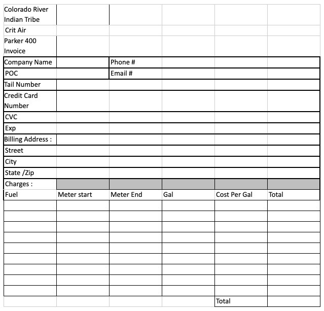
If you would like to save time fueling at the airport, please print this slip ahead of time and be ready to present at the airport:

Insurance:
Helicopter pilots must provide proof of commercial liability helicopter insurance naming “The Arizona Race Corp, Inc 29755 Kirsten LN, Vista CA 92084”, as additional insured, with no less than one million dollars per occurrence and two million dollars aggregate limits. Insurance certificates must be issued from an admitted carrier in the United States approved by the FAA, and specify that they provide coverage for commercial operations.
Television Crew:
Each year the Parker 400 production team works with a dedicated helicopter crew to document the Parker 400. They typically chase the leaders in each class for 5-10 minute bursts. Their number one goal is to catch passes. Position changes are critical for storytelling. Our team will radio your helicopter as they approach your airspace. Please help us by giving us some space to work and staying in good communication with us.
Military Operations Areas:
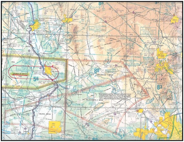
Please be aware of Military Operations Areas (MOAs) near the Parker 400 race course. These zones are used for military training and can pose safety risks. We have provided an attached map highlighting these areas for your reference. Always check this map and current NOTAMs for the latest information on MOA locations and activity times to ensure a safe flight path during the event. Avoiding these areas is crucial for the safety of all involved in the race.

Helicopter Spectating:
Helicopter spectating at the Parker 400 will be allowed on a limited, first come first basis. Helicopters wishing to spectate the race must adhere to all of the above listed rules and regulations. Spectating helicopters may not interfere with television or race team helicopters at any time. ALL of the same rules apply to spectating from a helicopter.
Colorado River Indian Tribes (CRIT) Fees:
In addition to your Parker 400 helicopter registration fee, the following fees will be paid directly to the Colorado River Indian Tribes (CRIT) at the airport.
- Landing Fee: There will be a one time $50 landing fee for chase helicopters.
- Flow Fee: If you are bringing your own fuel to the airport, there will be a one time flow fee of $40.
